
Anderson ZIP Directory Coverage
Official postal materials associate several codes with an Anderson label, but no stable federal neighborhood map was found. The Anderson ZIP code directory therefore reports only what the sources support. Codes 46011 through 46018 appear in Anderson postal material. Codes 46044 and 46051 entered an Anderson processing-label group in a 2024 bulletin, but that does not make every address in them part of Anderson city.
| ZIP Code | Areas Covered | Post Office | Notes |
|---|---|---|---|
| 46011 | Anderson postal-label service area | Anderson PO, Raible Avenue | Not city-limit proof |
| 46012 | Anderson postal-label service area | Anderson label | Validate the street |
| 46013 | Anderson postal-label service area | 2024 Anderson 46013 label | No district inference |
| 46014 | Anderson postal-label service area | 2024 routing change | Exact area map not found |
| 46015 | Anderson postal-label service area | 2024 grouping change | Check address and date |
| 46016 | Anderson postal area; many county offices | 2024 routing change | Postal and city labels differ |
| 46017 | Anderson postal-label service area | Anderson label | Exact area map not found |
| 46018 | Anderson postal-label service area | 2024 routing change | Not a municipal boundary |
| 46044, 46051 | Added to Anderson processing label | Anderson 46013 grouping | Do not call them city neighborhoods |
The table avoids invented neighborhood names. USPS sorts mail through delivery units and carrier routes, while Madison County and the city keep parcel and jurisdiction records. Those systems answer different questions. An address-level lookup is still needed before a code is attached to a person or property.
Search Anderson Postal Fields
The USPS ZIP Code Lookup has three distinct modes. By Address validates a delivery address. By City and State returns possible codes for a postal city. Cities by ZIP returns associated postal-city information. The result carries an important limit: a match does not prove that a person or company is present there.
| Mode | Fields | Best use |
|---|---|---|
| By Address | Street, city, state; optional company, unit, ZIP | Validate one complete delivery address |
| By City and State | City and state | List postal codes tied to Anderson |
| Cities by ZIP | ZIP | Check the postal-city label |
Enter unit details when known. A valid ZIP still says nothing about ownership, occupancy, ward, township, or city jurisdiction. Those facts need county or city records.
Anderson ZIP Labels Changed
A 2015 Postal Bulletin listed Anderson routing relationships for 46013 through 46017. A 2024 bulletin changed the processing label for 46013, 46014, 46016, and 46018 from Anderson 46011 to Anderson 46013. It deleted 46015 from the prior group and added 46044 and 46051 to the Anderson 46013 group.
This is the main geography quirk in the Anderson ZIP code directory. A routing-label update is not annexation, a neighborhood rename, or proof that a resident moved. When an old letter and a current database disagree, compare the full street, parcel, and date instead of forcing both sources into one postal label.
Keep the date. Record when the label was published, when the address appeared, and when the postal lookup was inspected.
Anderson Post Office Check
The Anderson Post Office is at 1505 Raible Avenue, Anderson, IN 46011-9998, with local phone 765-643-6363. Captured retail hours were weekdays 8:30 a.m. to 7:00 p.m. and Saturday 9:00 a.m. to 2:00 p.m.; hours should be checked before visiting. National customer service is 1-800-275-8777.
Check the current USPS location page before using the successful capture.
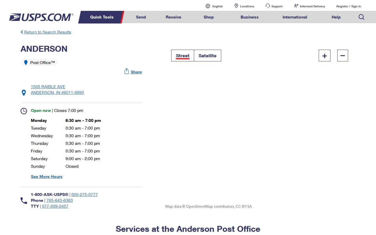
The image confirms the local postal contact. Staff can address delivery labels, but the county GIS or city office controls other jurisdiction questions.
Find Anderson Records by ZIP
A ZIP code directory can narrow the field, but each official source has its own controls. Madison County Beacon exposes an advanced ZIP field alongside address and city when the live screen is available. The Schneider parcel layer also contains a ZIP field. MyCase did not expose a ZIP-wide name search, and voter data by ZIP requires the lawful county request route rather than an assumed public bulk screen.
- Validate the complete address with USPS, including unit information.
- Search the Madison County property system by ZIP, then narrow by street or parcel number.
- Open the GIS parcel display and check the postal city against the parcel's jurisdiction fields.
- For voter data, ask the Madison Election Office about VRG-24, permitted fields, policy, and fees.
- Save the query date and verify any person through the record's official custodian.
Beacon ownership is not proof of occupancy, and a GIS layer is not a certified survey. Once the code has narrowed the area, use the Anderson street directory for the address-level chain. USPS is not the custodian of a resident list.
Check Anderson ZIPs in GIS
The Madison County GIS viewer provides map viewing, identification, and printing. The parcel schema can include street, city, state, ZIP, owner, legal description, parcel keys, sale fields, and values. MCCOG warns that the viewer is not a certified survey or substitute for the underlying public record.
Use GIS to compare the postal city with parcel geography, then contact the Auditor, Assessor, or city office when legal jurisdiction matters. The current research did not locate an official, stable neighborhood-by-ZIP map or an exact public ZIP result count. That gap should remain visible rather than being filled with guessed neighborhood boundaries.
Note: A parcel ZIP field reflects address data in that layer and may differ from a later USPS routing result.
Trace Older Anderson Postal Codes
The USPS Postmaster Finder searches historical post-office associations by a three-digit ZIP range. The Anderson Public Library Indiana Room adds city directories, Sanborn maps, local microfilm, old city maps, and a 1871 bird's-eye-view lead. These sources can explain an old mailing label, but none should be silently converted to a modern address.
Historical work should keep the street spelling and directory year, then test the modern address separately. Railroad maps from 1915 through 1917, corrected in 1959 and 1960, can also explain why an industrial or landmark-based address fails in a current postal form. Pair the old map or directory with a modern parcel key only after the location is confirmed.
Request Anderson Address Records
When a portal cannot answer an address or boundary question, identify the right custodian. USPS handles delivery labels. Madison County GIS, Auditor, and Assessor records handle parcel fields and county geography. Anderson Streets, Engineering, and Permit offices hold municipal work and addressing records within their duties.
Under the Indiana Access to Public Records Act, IC 5-14-3, request an existing city or county record by street, parcel, date, and record type. An office need not create a new ZIP-wide resident list or analysis. For historical address changes, the library and historical society are better routes than a current postal counter. Keep any office response, fee statement, delivery method, and redactions with the research notes.
Anderson ZIPs and City Limits
ZIP codes follow delivery units and carrier routes, not Anderson's municipal border. Madison County includes Anderson, other towns, and unincorporated land. A county parcel may display Anderson as its postal city without proving that it lies within the city. Census QuickFacts uses a city statistical boundary, while its population figures are not ZIP totals.
The Anderson ZIP code directory therefore does not assign Downtown, West Eighth Street, West Central, or any other named district to a code without an official address-level source. Validate USPS delivery, county parcel geography, and the city limit as separate facts. This prevents a postal processing change from being mistaken for annexation or resident movement.
- ZIP vs ZIP+4
- A five-digit delivery area versus the added four digits that narrow a delivery point or segment.
- PO-box ZIP
- A code used for post-office-box delivery rather than ordinary street delivery.
- Unique ZIP
- A code assigned to one large organization or destination.
- Carrier route
- A group of delivery points served along a postal route.
Use these terms as postal tools, not as labels for a person's legal residence. A result should always retain the full address and inspection date.